Loading
Get California Zip Code Map
How it works
-

Open form follow the instructions
-

Easily sign the form with your finger
-

Send filled & signed form or save
How to fill out the California Zip Code Map online
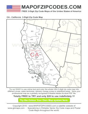
The California Zip Code Map is a helpful tool for visualizing and understanding the distribution of zip codes throughout the state. This guide will walk you through the steps needed to fill out the California Zip Code Map online effectively and efficiently.
Follow the steps to complete the California Zip Code Map online
- Press the ‘Get Form’ button to access the California Zip Code Map and open it in the editor for modifications.
- Carefully examine the sections of the map. Identify the areas you want to focus on, whether it is for sales territories, delivery charge zones, or statistical areas.
- Utilize the online tool to color the designated zones on the 3-digit zip code map. Be sure to select different colors for each zone to enhance clarity.
- Once satisfied with your adjustments, review the map for accuracy. Make any necessary changes to ensure it meets your requirements.
- When you are finished, you have the option to save your color-coded map as an Editable Adobe Acrobat PDF file. This allows for easy sharing and distribution.
- Download, print, or share your completed map as needed, ensuring others can also benefit from your work.
Start creating your California Zip Code Map online today!
California Area Codes 209/350*530831213/323/738*559909/840*310/424*562916/279*408/669*619/858*925415/628*6269491 more row
Industry-leading security and compliance
US Legal Forms protects your data by complying with industry-specific security standards.
-
In businnes since 199725+ years providing professional legal documents.
-
Accredited businessGuarantees that a business meets BBB accreditation standards in the US and Canada.
-
Secured by BraintreeValidated Level 1 PCI DSS compliant payment gateway that accepts most major credit and debit card brands from across the globe.