Loading
Get Topographic Features Of The Taku Glacier Region Lab Answers
How it works
-

Open form follow the instructions
-

Easily sign the form with your finger
-

Send filled & signed form or save
How to fill out the Topographic Features Of The Taku Glacier Region Lab Answers online
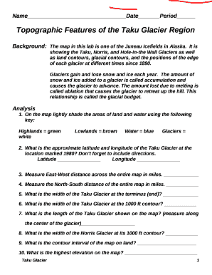
Filling out the Topographic Features Of The Taku Glacier Region Lab Answers form can be an insightful experience, allowing users to engage with the geographic and environmental features of the Taku Glacier. This guide provides a step-by-step approach to assist users in completing the document accurately and efficiently.
Follow the steps to complete the lab answers form
- Click ‘Get Form’ button to access the form and open it in the editing space.
- Begin by entering your name, date, and period at the top of the form. Ensure that your inputs are clear and legible.
- In the background section, review the information about the Taku Glacier and its characteristics that are essential for context.
- Proceed to the analysis section. For item 1, use appropriate colors to lightly shade the areas of land and water based on the provided key.
- For items 2 through 10, provide geographical measurements and observations as indicated. Enter approximate latitude and longitude for the Taku Glacier, along with measurements of distances in miles.
- Continue with items 11 through 22, answering each question based on the information available on the map and your observations. Make sure to explain and justify your answers where applicable.
- Once all sections are completed, review the document for any errors or omissions. Ensure that all answers are substantiated as per the lab requirements.
- Finally, save your changes. You may download, print, or share the completed form according to your needs.
Complete your lab answers online today for a comprehensive understanding of the Taku Glacier Region!
So, the width of Taku Glaciers at its 1000ft contour line is approximately 2 mi…
Industry-leading security and compliance
US Legal Forms protects your data by complying with industry-specific security standards.
-
In businnes since 199725+ years providing professional legal documents.
-
Accredited businessGuarantees that a business meets BBB accreditation standards in the US and Canada.
-
Secured by BraintreeValidated Level 1 PCI DSS compliant payment gateway that accepts most major credit and debit card brands from across the globe.