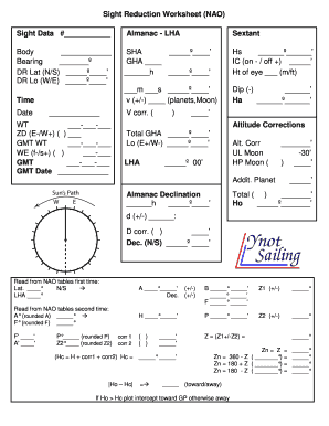
Sight Reduction Worksheet (NAO) Sight Data # Almanac LHA Sextant Body Bearing DR Lat (N/S) DR Lo (W/E) SHA GHA h Hs IC (on / off +) Ht of eye (m/ft) m s v (+/) (planets,Moon) Dip () Ha Time Date V.
Open form follow the instructions
Easily sign the form with your finger
Send filled & signed form or save
How to fill out the Sight Reduction Worksheet online
The Sight Reduction Worksheet is an essential tool for navigators to determine their position at sea. This guide offers a step-by-step approach to filling out the form online, ensuring a clear understanding of each component.
Follow the steps to successfully complete the Sight Reduction Worksheet online
- Click the ‘Get Form’ button to access the Sight Reduction Worksheet and open it in your preferred editor.
- Begin by entering your sight data in the designated fields, such as the almanac data, bearing, and coordinates (DR Latitude and Longitude). Make sure to input accurate details to enhance the precision of your results.
- Fill in the details for the physical observations including SHA (Sidereal Hour Angle), GHA (Greenwich Hour Angle), and the height of the eye. This section is crucial for calculating your altitude corrections.
- Record the necessary time and date information accurately; this is critical for determining the correct celestial data in relation to your observations.
- Proceed to make altitude corrections as prompted in the worksheet. Ensure each entry reflects the necessary adjustments from your readings.
- Utilize the NAO tables to extract values for latitude and LHA adjustments based on your recorded data. Cross-reference to ensure accuracy.
- Complete the final calculations based on your values for Ho (observed altitude) and Hc (calculated altitude). Document the differences and corrections required.
- Once all data entries and calculations are complete, review your form for any discrepancies. Ensure all fields are filled appropriately before saving your work.
- Finally, save your changes. You can choose to download, print, or share the completed Sight Reduction Worksheet as needed.
Complete your Sight Reduction Worksheet online for seamless navigation and accurate position fixing.
Experience a faster way to fill out and sign forms on the web. Access the most extensive library of templates available.
Related content
Dec 3, 2020 — If opposing roadway traffic volumes were collected, include in the...
The Nautical Almanac and The Sight Reduction Tables for Marine Navigation (Publication...
In navigation, sight reduction is the process of deriving from a sight the information...
Get answers to your most pressing questions about US Legal Forms API.
What is the first step in sight reduction method?
“Sight reduction”, is a term given to the way a sextant sight is transformed into a line of position on a chart. It is what the so called “math” concerning celestial navigation is all about. The simplest method of sight reduction is to draw a circle of equal altitude of a celestial body on an Earth globe.
How do you use sight reduction?
Step-by-step sight reduction Start with Hs, the angle that you read off of your sextant. Apply the index correction. Correct for height of eye using the dip table on the inside front cover of the Nautical Almanac. ... Determine and apply the main sun correction from the inside front cover of the Nautical Almanac.
What is sight reduction form?
Your observed measurements with the sextant, combined with data from these tables allow you to obtain the necessary coordinates to plot a Line of Position with some simple addition and subtraction. This process, called a sight reduction, is guided by the Sight Reduction Form.
What is a sight reduction table?
They are designed to facilitate the practice of celestial navigation at sea. The tables are primarily used with the Intercept method of sight reduction by entering arguments of latitude, declination, and Local Hour Angle and obtaining tabulated altitudes and azimuth angles.
What is 249 sight reduction tables for marine navigation?
The Sight Reduction Tables for Air Navigation (Pub 249) consist of three volumes of comprehensive tables of altitude and azimuth designed for the rapid reduction of astronomical sights in the air.
What is originally known as concise tables for sight reduction?
The Nautical Almanac Sight Reduction (NASR, originally known as Concise Tables for Sight Reduction or Davies, 1984, 22pg) Pub. 249 (formerly H.O. 249, Sight Reduction Tables for Air Navigation, A.P.
What is the purpose of sight reduction table in Nautical Almanac?
Sight Reduction Tables are used in celestial navigation to "reduce" (analyze) the "sights" (data obtained from a sextant at known times) in order to find your latitude and longitude.
Use professional pre-built templates to fill in and sign documents online faster. Get access to thousands of forms.
If you believe that this page should be taken down, please follow our DMCA take down process here.