Loading
Get Big River Journey Classroom Activity: Geography
How it works
-

Open form follow the instructions
-

Easily sign the form with your finger
-

Send filled & signed form or save
How to fill out the Big River Journey Classroom Activity: Geography online
This guide will assist you in effectively completing the Big River Journey Classroom Activity: Geography. Follow the step-by-step instructions to ensure that you accurately fill out the essential components of the form online.
Follow the steps to successfully complete the form.
- Press the 'Get Form' button to access the form and open it for editing.
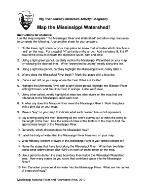
- Begin by locating the lower right corner of your map and place an arrow that indicates north. Make sure to write a capital 'N' at the tip and add the letters 'S', 'E', and 'W' to indicate south, east, and west directions.
- Using a light green pencil, carefully trace the outline of the Mississippi Watershed by following the dashed lines on your map. Neatly write 'watershed boundary' along this line.
- Adopt a light blue pencil to highlight the path of the Mississippi River and make sure to label it clearly.
- Identify the starting point of the Mississippi River and mark that location with a blue dot.
- On your map, place a red dot where the Twin Cities are situated.
- Use a light yellow pencil to highlight the Minnesota River, a light brown pencil for the Missouri River, and an orange pencil for the Ohio River. Make sure to label each river.
- Choose additional colors to neatly highlight at least two more rivers that are tributaries to the Mississippi River, labeling each accordingly.
- On the map, denote where the Missouri River meets the Mississippi River by placing a pink dot.
- Create a key on your map to indicate what each colored line or dot signifies.
- Lay a piece of string along the river's course, trimming it to match the length of the river. Utilize the scale of miles provided on the bottom of the map to estimate the Mississippi River's length.
- Identify the general direction in which the Mississippi flows.
- Label the body of water where the Mississippi River flows into on your map.
- Determine which tributary of the Mississippi River is closest to your school and mark it.
- List the states that share land along the Mississippi River and write their two-letter postal code abbreviations on each respective state on the map.
- Using a pencil, darken the boundary lines of the states within the Mississippi Watershed. Count how many states contribute water to the Mississippi River.
- Identify the names of the two Canadian provinces that drain water into the Mississippi River.
- Once you have completed all the steps, remember to save your changes, download the finalized document, print it out, or share the completed form as needed.
Start filling out the Big River Journey Classroom Activity: Geography online now!