Loading
Get Canada Map Assignment
How it works
-

Open form follow the instructions
-

Easily sign the form with your finger
-

Send filled & signed form or save
How to fill out the Canada Map Assignment online
Filling out the Canada Map Assignment online requires careful attention to detail and creativity. This guide will walk you through each step to ensure you complete the assignment accurately and effectively.
Follow the steps to complete your assignment successfully.
- Click ‘Get Form’ button to access the Canada Map Assignment and open it for editing.
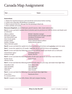
- Read all instructions thoroughly before beginning. Gather the necessary resources: pencil, black pen, pencil crayons, ruler, eraser, and atlas.
- In Part A, locate and label Canada's three territories and ten provinces in capital letters. Use the specified colors for shading each province or territory as indicated.
- Proceed to Part B, where you will locate and label the capital city of each province and territory, underlining each city name clearly.
- In Part C, find and label the capital city of Canada. Ensure that the city name is in capital letters and underlined.
- Moving to Part D, locate and label the specified countries, shading each as indicated.
- For Part E, locate and label the bodies of salt water, shading all ocean water in dark blue.
- In Part F, locate and label the bodies of fresh water on your map, shading them in light blue.
- Proceed to Part G to locate and label the designated rivers and shade them in light blue.
- Finally, complete your map with a frame, title, and compass bearing, labeling it as 'Canada Map'.
- Once you have filled out all sections, carefully review your work, save any changes, and proceed to download, print, or share your completed assignment.
Complete your Canada Map Assignment online today!
Topographic map coverage of Canada is based on the National Topographic System (NTS).