We use cookies to improve security, personalize the user experience, enhance our marketing activities (including cooperating with our marketing partners) and for other business use.
Click "here" to read our Cookie Policy. By clicking "Accept" you agree to the use of cookies. Read less
Read more
Accept
Loading
Form preview
  • US Legal Forms
  • Form Library
  • More Forms
  • More Uncategorized Forms
  • Part 1 Project Overview - Metro Gis - Metrogis

Get Part 1 Project Overview - Metro Gis - Metrogis

MetroGIS Project Proposal Template Version 1.0 1 MetroGIS provides an ongoing opportunity for collaborative projects among its stakeholders. Crucial to the success of collaborative projects are the.

How it works

  1. Open form

    Open form follow the instructions

  2. Easily sign form

    Easily sign the form with your finger

  3. Share form

    Send filled & signed form or save

How to fill out the Part 1 Project Overview - Metro GIS - Metrogis online

This guide provides a comprehensive overview of how to effectively fill out the Part 1 Project Overview for the Metro GIS - Metrogis. By following the structured steps outlined below, users can clearly and accurately document their project details.

Follow the steps to successfully complete the Project Overview form.

  1. Click ‘Get Form’ button to access the Project Overview form and open it in the online editor.
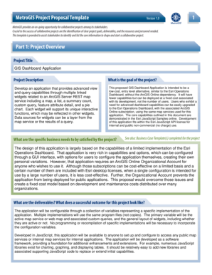
  2. Enter the project title in the designated field. Provide a concise and descriptive title for your project, ensuring it reflects the main objective.
  3. In the project description section, detail the functionalities and capabilities of the proposed application. Include any specific features and user interactions that make this project innovative.
  4. Clearly define the project's goals. State what the project aims to achieve, focusing on its importance and benefits for users.
  5. Identify the specific business needs that this project addresses. Highlight any gaps that exist and how the project intends to fill them.
  6. Outline the deliverables of the project. Describe what a successful outcome looks like and how the application will serve its intended purpose.
  7. Make sure to review all information entered for accuracy and completeness. Ensure that every relevant detail is included.
  8. Once satisfied with the form, proceed to save your changes. You may also download, print, or share the completed form as needed.

Take the next step and complete your Project Overview form online today!

Get form

Experience a faster way to fill out and sign forms on the web. Access the most extensive library of templates available.
Get form

Related content

Metadata: Metro Collaborative Parks - FTP...
Overview — Section 1: Overview ... the Metro Parks Collaborative, a joint collaborative...
Learn more
(PDF) Metropolitan GIS: The Minnesota Metadata...
It facilitated MetroGIS cre- tion methods is also necessary. ation and provided a...
Learn more
Index över Minnesota-relaterade artiklar - Index...
allmänhet: Kategori: Kartor över Minnesota · Maritime Heritage Minnesota · MetroGIS ·...
Learn more

Related links form

Term Sheet - Mezzanine Debt - Arch Capital Advisors Swimming Membership Form 2020 Weekly Reading Log COMM I NWEALTH OF PENNSYLVANIA - Senda 2020

Questions & Answers

Get answers to your most pressing questions about US Legal Forms API.

Contact support

GIS tools are designed to analyze and visualize this spatial data, and it happens in three steps: Visualize data: The system displays geographic data. Combing data: Maps are created with layers of data. Query data: Geographic queries look for insights and information in the layered data.

The realization of a GIS project can be conceptualized in 5 main steps: definition of the research question, the design of the methodology, the data gathering, the analysis, the presentation of the results.

A GIS is often used in a sequence of processes or operations that is referred to as the GIS cycle (Figure 1). This cycle starts with the real world and then moves through measurement, data entry, retrieval, analysis, uncertainty analysis, output, decision- making and action.

Process Needed to Complete GIS Analysis Step 1: Formulate the problem. This step seems easy, because you are usually assigned a project to perform specific information. ... Step 2: Check and prepare the data. This step may take longer. ... Step 3: Selecting tools and analysis methods. ... Step 4: Perform analysis. ... The fifth step :

General-purpose GIS software performs six major tasks such as input, manipulation, management, query and analysis, Visualization. The important input data for any GIS is digitized maps, images, spatial data and tabular data.

Get This Form Now!

Use professional pre-built templates to fill in and sign documents online faster. Get access to thousands of forms.
Get form
If you believe that this page should be taken down, please follow our DMCA take down processhere.

Industry-leading security and compliance

US Legal Forms protects your data by complying with industry-specific security standards.
  • In businnes since 1997
    25+ years providing professional legal documents.
  • Accredited business
    Guarantees that a business meets BBB accreditation standards in the US and Canada.
  • Secured by Braintree
    Validated Level 1 PCI DSS compliant payment gateway that accepts most major credit and debit card brands from across the globe.
Get Part 1 Project Overview - Metro GIS - Metrogis
Get form
Form Packages
Adoption
Bankruptcy
Contractors
Divorce
Home Sales
Employment
Identity Theft
Incorporation
Landlord Tenant
Living Trust
Name Change
Personal Planning
Small Business
Wills & Estates
Packages A-Z
Form Categories
Affidavits
Bankruptcy
Bill of Sale
Corporate - LLC
Divorce
Employment
Identity Theft
Internet Technology
Landlord Tenant
Living Wills
Name Change
Power of Attorney
Real Estate
Small Estates
Wills
All Forms
Forms A-Z
Form Library
Customer Service
Terms of Service
Privacy Notice
Legal Hub
Content Takedown Policy
Bug Bounty Program
About Us
Blog
Affiliates
Contact Us
Delete My Account
Site Map
Industries
Forms in Spanish
Localized Forms
State-specific Forms
Forms Kit
Legal Guides
Real Estate Handbook
All Guides
Prepared for You
Notarize
Incorporation services
Our Customers
For Consumers
For Small Business
For Attorneys
Our Sites
US Legal Forms
USLegal
FormsPass
pdfFiller
signNow
airSlate WorkFlow
DocHub
Instapage
Social Media
Call us now toll free:
+1 833 426 79 33
As seen in:
  • USA Today logo picture
  • CBC News logo picture
  • LA Times logo picture
  • The Washington Post logo picture
  • AP logo picture
  • Forbes logo picture
© Copyright 1997-2025
airSlate Legal Forms, Inc.
3720 Flowood Dr, Flowood, Mississippi 39232