Loading
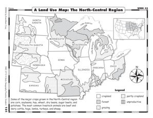
Get A Land Use Map The North Central Region
How it works
-

Open form follow the instructions
-

Easily sign the form with your finger
-

Send filled & signed form or save
How to fill out the A Land Use Map The North Central Region online
Filling out the A Land Use Map for the North Central Region online is a straightforward process that allows you to visualize and analyze land use data. This guide provides step-by-step instructions to help you complete the form accurately and efficiently.
Follow the steps to successfully fill out the form online.
- Press the ‘Get Form’ button to retrieve the form and open it in the available editor.
- Begin by entering your name in the specified field at the top of the form. This helps identify your submission and maintain records.
- Next, review the information shown on the map. In the first question, describe what key data and features are represented, focusing on crops and livestock in the North Central Region.
- In the second question, count the number of states displayed on the map. Identify how many of those states contain usable cropland, and document your findings clearly.
- For the following days, continue with the subsequent inquiries. Record the states that have good grazing lands for livestock and specify which state has the smallest amount of unproductive land based on your research.
- Week through the questions, detailing crops and livestock found in the region as per the prompts. Ensure that all sections are filled out comprehensively, applying the data you have gathered.
- After completing all sections, review your responses for completeness and accuracy.
- Finally, you can save your changes, download the completed form, or print and share your findings based on your needs.
Complete your A Land Use Map online today to enhance your understanding of land use in the North Central Region.
Which states border Lake Superior? Which land use categories do they all have in common? Michigan, Minnesota, and Wisconsin; cropland, partly cropland, and forest.