Loading
Get Example Of Wetland Delineation Filled Out
How it works
-

Open form follow the instructions
-

Easily sign the form with your finger
-

Send filled & signed form or save
How to fill out the Example Of Wetland Delineation Filled Out online
Filling out the Example Of Wetland Delineation Filled Out form requires careful attention to detail to ensure all necessary information is accurately provided. This guide will walk users through each section of the form, providing clear instructions for completion.
Follow the steps to successfully complete the form online.
- Press the ‘Get Form’ button to access the form and open it in your preferred document editing tool.
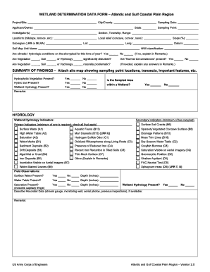
- Begin by entering the city or county where the project or site is located. This provides essential context for the wetland delineation.
- Fill in the project or site name, followed by the date of sampling and the state in which the work is being conducted.
- Include the name of the applicant or owner and the investigator or investigators involved in the project.
- Specify the section, township, and range of the property, as well as the local landform such as hillslope or terrace.
- Indicate the local relief type (concave, convex, none) and include latitude and longitude coordinates.
- Fill in the appropriate subregion, indicated by LRR or MLRA, along with the sampling point location.
- Provide the slope percentage and datum used for your measurements.
- In the NWI classification section, indicate the classification applicable to your site.
- Respond to the questions regarding climatic and hydrologic conditions, and provide explanations in the remarks section as necessary.
- Indicate whether vegetation, soil, or hydrology have been significantly disturbed and whether 'Normal Circumstances' are present.
- Complete the summary of findings section by checking if hydrophytic vegetation, hydric soil, and wetland hydrology are present, along with their corresponding indicators.
- In the hydrology section, detail the secondary and primary indicators by checking applicable items.
- For the vegetation section, list species observed in the four intended strata, ensuring the scientific names are included.
- In the soil section, provide comprehensive profile descriptions and include any relevant hydric soil indicators.
- Review all responses and ensure that explanations are provided in the remarks section when necessary.
- Once all fields are accurately filled, save the document, and choose to download, print, or share it as required.
Complete your documents online to ensure a smooth filing process.
How long will it take? Depending on the size of the site and potential wetland or poorly drained areas to evaluate, it can take 1-2 days to review and obtain the desktop research materials, and 1-2 field days to gather necessary site data (this timeline could be longer for more larger/more complex sites).
Industry-leading security and compliance
US Legal Forms protects your data by complying with industry-specific security standards.
-
In businnes since 199725+ years providing professional legal documents.
-
Accredited businessGuarantees that a business meets BBB accreditation standards in the US and Canada.
-
Secured by BraintreeValidated Level 1 PCI DSS compliant payment gateway that accepts most major credit and debit card brands from across the globe.