We use cookies to improve security, personalize the user experience, enhance our marketing activities (including cooperating with our marketing partners) and for other business use.
Click "here" to read our Cookie Policy. By clicking "Accept" you agree to the use of cookies. Read less
Read more
Accept
Loading
Form preview
  • US Legal Forms
  • Form Library
  • More Forms
  • More Uncategorized Forms
  • Wetland Determination Data Form Midwest Region ... - Nrcs Usda

Get Wetland Determination Data Form Midwest Region ... - Nrcs Usda

Reset Form Print Form WETLAND DETERMINATION DATA FORM Midwest Region City/County: Project/Site: Sampling Date: Applicant/Owner: State: Investigator(s): Section, Township, Range: Local relief (concave,.

How it works

  1. Open form

    Open form follow the instructions

  2. Easily sign form

    Easily sign the form with your finger

  3. Share form

    Send filled & signed form or save

How to use or fill out the WETLAND DETERMINATION DATA FORM Midwest Region - Nrcs Usda online

Filling out the WETLAND DETERMINATION DATA FORM is a crucial step in assessing wetland areas in the Midwest Region. This guide provides detailed instructions on how to accurately complete each section of the form, ensuring a thorough and effective submission process.

Follow the steps to complete the WETLAND DETERMINATION DATA FORM.

  1. Press the ‘Get Form’ button to access the form and open it in your preferred format.
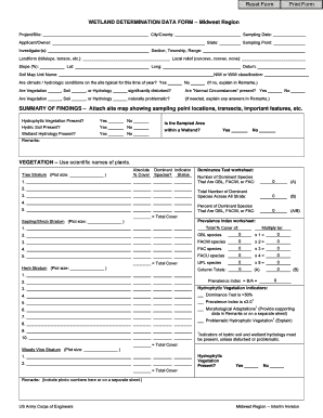
  2. Fill in the city or county information in the first section. It's essential to provide accurate data because it helps identify the specific location related to the wetland determination.
  3. Enter the project or site name, followed by the sampling date. This information is vital in documenting when and where the sampling took place.
  4. Complete the applicant or owner section with the name of the individual or organization responsible for the site.
  5. Specify the state where the sampling is taking place, followed by details about the investigator(s) involved in the assessment.
  6. Provide the section, township, and range information, along with local relief, landform type, and slope percentage to give a clearer topographic context of the area.
  7. Document the latitude and longitude coordinates of the sampling point along with the datum used for reference.
  8. Fill out the soil map unit name and indicate the NWI or WWI classification relevant to the area.
  9. Respond to the questions regarding climatic/hydrologic conditions, potential disturbances to vegetation, soil, or hydrology, and the presence of 'Normal Circumstances'.
  10. In the summary of findings, indicate the presence of hydrophytic vegetation, hydric soil, and wetland hydrology. Mark 'yes' or 'no' as appropriate.
  11. In the vegetation section, document plant species using their scientific names, and fill out the required indicators and tests as instructed.
  12. For soil documentation, provide a detailed profile description, including matrix color and redox features at specified depths.
  13. In the hydrology section, check off applicable wetland hydrology indicators and note observations regarding surface water and water table presence.
  14. Finally, review all sections for completeness and accuracy. You can save changes, download, print, or share the completed form as needed.

Complete your WETLAND DETERMINATION DATA FORM online today and ensure accurate documentation for effective wetland assessments.

Get form

Experience a faster way to fill out and sign forms on the web. Access the most extensive library of templates available.
Get form

Related content

WETLAND DETERMINATION DATA FORM – Midwest Region...
Hydric Soil Indicators: Indicators for Problematic Hydric Soils3: Histosol (A1). Sandy...
Learn more
List of useful wetland links - Illinois Natural...
Regional Supplement to the COE Wetland Delineation Manual - Midwest Region ... Chicago...
Learn more
safe waters, healthy waters - NCTCOG.org
fecal indicator bacteria provides a practical method to determine the potential health...
Learn more

Related links form

PERMISSION TO AN INDIVIDUAL FOR RIGHTS TO ... Safety Pledge Certificate Termination Lease Landlord Tenant Antenatal Record (Part 1)

Questions & Answers

Get answers to your most pressing questions about US Legal Forms API.

Contact support

Delineation is an act of locating the boundary or border of a wetland or watercourse. Delineation also includes providing a geographical location in the landscape as well describes the functions and values the wetland or watercourse.

A wetland delineation is a procedure that determines the location and extent of wetlands on a property. This is typically completed before a property can be developed due to state and federal laws that regulate fill or drainage of wetlands.

Indicator 2: Dominance Test. The “50/20 rule”: ▪ More than 50 percent of the dominant plant species across all strata are rated OBL, FACW, or FAC.

A stream or wetland delineation study involves a thorough investigation of any critical areas on-site. The critical area boundary is flagged and displayed on a map along with the associated buffer width. The map is presented in a report that may be used for permitting as well as site layout.

For this classification, wetlands must have one or more of the following three attributes: (1) at least periodically; the land supports hydrophytes predominantly; (2) the substrate is predominantly undrained hydric soil; and (3) the substrate is nonsoil and is saturated with water or covered by shallow water at some ...

All watershed delineation means is that you're drawing lines on a map to identify a watershed's boundaries. These are typically drawn on topographic maps using information from contour lines. Contour lines are lines of equal elevation, so any point along a given contour line is the same elevation. Page 3.

As discussed earlier, an area must meet three specific criteria to be considered a wetland: First, a wetland must have hydrological indicators. Secondly, only specific types of Vegetation can grow in a wetland. Lastly, a wetland must have specific soil conditions. Most wetlands have all three characteristics.

This protocol uses three criteria for identifying and delineating wetlands: vegetation, soils, and hydrology, which have been adapted to New Zealand conditions. The Wetland delineation protocols give a robust method for delineating wetlands based on the United States delineation system.

Get This Form Now!

Use professional pre-built templates to fill in and sign documents online faster. Get access to thousands of forms.
Get form
If you believe that this page should be taken down, please follow our DMCA take down processhere.

Industry-leading security and compliance

US Legal Forms protects your data by complying with industry-specific security standards.
  • In businnes since 1997
    25+ years providing professional legal documents.
  • Accredited business
    Guarantees that a business meets BBB accreditation standards in the US and Canada.
  • Secured by Braintree
    Validated Level 1 PCI DSS compliant payment gateway that accepts most major credit and debit card brands from across the globe.
Get WETLAND DETERMINATION DATA FORM Midwest Region ... - Nrcs Usda
Get form
Form Packages
Adoption
Bankruptcy
Contractors
Divorce
Home Sales
Employment
Identity Theft
Incorporation
Landlord Tenant
Living Trust
Name Change
Personal Planning
Small Business
Wills & Estates
Packages A-Z
Form Categories
Affidavits
Bankruptcy
Bill of Sale
Corporate - LLC
Divorce
Employment
Identity Theft
Internet Technology
Landlord Tenant
Living Wills
Name Change
Power of Attorney
Real Estate
Small Estates
Wills
All Forms
Forms A-Z
Form Library
Customer Service
Terms of Service
Privacy Notice
Legal Hub
Content Takedown Policy
Bug Bounty Program
About Us
Blog
Affiliates
Contact Us
Delete My Account
Site Map
Industries
Forms in Spanish
Localized Forms
State-specific Forms
Forms Kit
Legal Guides
Real Estate Handbook
All Guides
Prepared for You
Notarize
Incorporation services
Our Customers
For Consumers
For Small Business
For Attorneys
Our Sites
US Legal Forms
USLegal
FormsPass
pdfFiller
signNow
airSlate WorkFlow
DocHub
Instapage
Social Media
Call us now toll free:
+1 833 426 79 33
As seen in:
  • USA Today logo picture
  • CBC News logo picture
  • LA Times logo picture
  • The Washington Post logo picture
  • AP logo picture
  • Forbes logo picture
© Copyright 1997-2025
airSlate Legal Forms, Inc.
3720 Flowood Dr, Flowood, Mississippi 39232