Loading
Get Lucas Eurostat Form
How it works
-

Open form follow the instructions
-

Easily sign the form with your finger
-

Send filled & signed form or save
How to fill out the Lucas Eurostat Form online
The Lucas Eurostat Form is a vital document used for collecting data on land use and cover across Europe. This guide provides a detailed overview and step-by-step instructions on how to accurately fill out this form online, ensuring compliance and ease of use.
Follow the steps to complete the Lucas Eurostat Form with ease.
- Press the ‘Get Form’ button to retrieve the Lucas Eurostat Form and open it in a suitable editor.
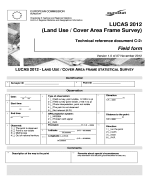
- Begin with the identification section. Fill in your surveyor ID and point ID as indicated.
- Input the observation date and times for start and end as per the specified format (DD/MM).
- Select the visibility status of the observation by checking the appropriate box for options regarding the point's visibility.
- Indicate the type of observation by checking the relevant box that best describes your situation.
- Fill out the GPS projection system used, precision, latitude, and longitude as required.
- Record the distance to the observation point and elevation.
- Provide the direction of the observation as indicated.
- Include comments about the description of the way to the point and any remarks regarding special circumstances.
- Proceed to the land cover and land use section. Enter relevant data for land cover species, area size, and percentages of land coverage.
- Fill in information about land management, special status, and water management as applicable.
- Address the soil section by indicating if a soil sample was taken and providing necessary remarks.
- Lastly, complete the transect section by noting any relevant information, including photos if taken.
- Once all sections are filled out, review the form for completeness, then you can save changes, download, print, or share the completed form.
Start filling out your Lucas Eurostat Form online today!
The 'Land Use/Cover Area frame statistical Survey Soil' (LUCAS Soil) is an extensive and regular topsoil survey that is carried out across the European Union to derive policy-relevant statistics on the effect of land management on soil characteristics.