Loading
Get Parcel Map Bapplicationb - City Of Chowchilla
How it works
-

Open form follow the instructions
-

Easily sign the form with your finger
-

Send filled & signed form or save
How to fill out the Parcel Map Application - City Of Chowchilla online
The Parcel Map Application for the City of Chowchilla is a crucial document for individuals seeking to subdivide land. This guide provides clear, step-by-step instructions to assist users in completing the form accurately, ensuring compliance with city regulations.
Follow the steps to successfully complete your parcel map application.
- Click ‘Get Form’ button to obtain the Parcel Map Application form and open it in your preferred editor.
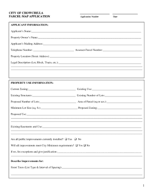
- Fill in the applicant information section, including the applicant’s name, property owner’s name, mailing address, telephone number, assessor parcel number, property location, and a legal description of the property.
- Complete the property use information section by providing current zoning, existing use, existing structures, the current and proposed number of lots, area of the parcel, minimum lot size, proposed zoning, and proposed use.
- Indicate whether all public improvements are currently installed and if those improvements meet city minimum requirements. If not, list any exceptions and provide justifications.
- Describe any improvements related to street trees, drainage collection and disposal, domestic water supply, proposed sewer collection, and other public utilities.
- Attach a preliminary title report detailing the interests in the parcel as required.
- Review the certification section, ensuring that the owner of the property certifies they are the owner and have examined the submitted map.
- Complete the signature and printed name sections for the property owner and their agent, along with their contact information.
- Ensure that any additional required maps and application materials are prepared and submitted to the Planning Department.
- Once all fields are completed, save your changes, and choose to download, print, or share the completed Parcel Map Application form.
Start your application process now by completing the Parcel Map Application online.
WHAT IS A PARCEL MAP (PM)? A “parcel map” is a land division map processed through the Planning and Natural Resources Department resulting in the creation of four (4) or fewer lots, which is specifically authorized by the State Subdivision Map Act and Chapter 18.25 of the Kern County Land Division Ordinance.
Industry-leading security and compliance
US Legal Forms protects your data by complying with industry-specific security standards.
-
In businnes since 199725+ years providing professional legal documents.
-
Accredited businessGuarantees that a business meets BBB accreditation standards in the US and Canada.
-
Secured by BraintreeValidated Level 1 PCI DSS compliant payment gateway that accepts most major credit and debit card brands from across the globe.