Loading
Get Alaska Public Water System Locational Data Collection Form - Dec State Ak
How it works
-

Open form follow the instructions
-

Easily sign the form with your finger
-

Send filled & signed form or save
How to fill out the Alaska Public Water System Locational Data Collection Form - Dec State Ak online
This guide provides you with clear instructions on how to complete the Alaska Public Water System Locational Data Collection Form online. The form is essential for collecting locational data related to public water systems in Alaska.
Follow the steps to fill out the form accurately and efficiently.
- Press the ‘Get Form’ button to access the form and open it for online completion.
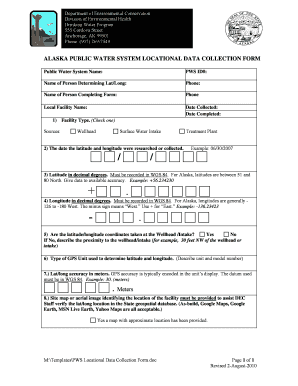
- Enter the Public Water System Name in the designated field. This should be the official name of the water system.
- Fill in the PWS ID# which is a unique identifier assigned to the water system.
- Provide the name and phone number of the person determining the latitude and longitude by filling in the respective fields.
- Complete the information for the person filling out the form, including their name and contact number.
- Specify the local facility name where the water system is located.
- Enter the date when the data was collected and the date when the form is completed.
- In the facility type section, check one box to indicate the type of source, which could be Wellhead or Surface Water Intake.
- Input the date when latitude and longitude were researched or collected.
- Record the latitude in decimal degrees, ensuring it is in WGS 84 format. Provide the data with available accuracy.
- Enter the longitude in decimal degrees, following the same format as the latitude.
- Indicate whether the coordinates were taken at the wellhead/intake, and if 'No', describe the proximity accurately.
- Describe the type of GPS unit used to determine latitude and longitude, including the model number.
- Provide the latitude and longitude accuracy in meters, as indicated by the GPS unit.
- Attach a site map or aerial image that identifies the location of the facility to assist the Department of Environmental Conservation (DEC) staff in verifying data.
- Once all fields are completed, save the changes, download the completed form, and share it as necessary.
Complete your submission of the Alaska Public Water System Locational Data Collection Form online today!
A watermarking system is usually divided into three distinct steps, embedding, attack, and detection. In embedding, an algorithm accepts the host and the data to be embedded, and produces a watermarked signal. Then the watermarked digital signal is transmitted or stored, usually transmitted to another person.
Industry-leading security and compliance
US Legal Forms protects your data by complying with industry-specific security standards.
-
In businnes since 199725+ years providing professional legal documents.
-
Accredited businessGuarantees that a business meets BBB accreditation standards in the US and Canada.
-
Secured by BraintreeValidated Level 1 PCI DSS compliant payment gateway that accepts most major credit and debit card brands from across the globe.