Get Gps Observation Log Sheet - Faa Airports Gis Program - Federal ...
How it works
-

Open form follow the instructions
-

Easily sign the form with your finger
-

Send filled & signed form or save
How to use or fill out the GPS Observation Log Sheet - FAA Airports GIS Program - Federal ... online
This guide provides step-by-step instructions on how to accurately fill out the GPS Observation Log Sheet for the FAA Airports GIS Program online. It aims to assist users in completing the form with confidence and clarity.
Follow the steps to fill out the GPS observation log sheet effectively.
- Press the ‘Get Form’ button to retrieve the GPS Observation Log Sheet and open it for editing.
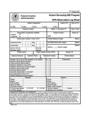
- Begin by filling in the station designation, selecting the appropriate option such as FBN or CBN, and enter the Station PID.
- Provide the general location details by entering the geographic coordinates (NAD83), including both latitude and longitude in the specified format.
- Input the observation session times in Coordinated Universal Time (UTC), specifying the scheduled and actual start and stop times.
- Enter the epoch interval and elevation mask, followed by the project name and the agency or company associated with the project.
- Fill in the date in UTC format, and provide the four-character station ID, day of the year, project number, and airport ID.
- Record the GPS NAD83 ellipsoid height and NAVD88 orthometric height in meters, and specify the GEOID.
- Document the session ID, operator's name, contact telephone number, and email address.
- Answer the series of yes/no questions regarding the antenna setup and observations, providing explanations where necessary.
- Include the details of the receiver and antenna, noting brand, model, part number, and serial number where applicable.
- Indicate the vehicle's parking distance and direction from the antenna if relevant.
- If applicable, provide details about any equipment used, including tripods and weather instruments.
- Enter any measurements related to height and offsets, ensuring to convert between meters and feet where necessary.
- Record relevant weather data during the observation session, including temperature, humidity, and atmospheric pressure at various times.
- Attach or submit any additional documents required, including station location sketches, photographs, and pencil rubbings.
- Finally, have the log checked by a qualified person, noting their printed name and initials, and provide any remarks or comments.
Complete your GPS Observation Log Sheet online today to ensure accurate documentation!
The 14 CFR Part 139 requirements are mandatory for ensuring that airports maintain safety and operational standards. These regulations focus on various aspects, including airport maintenance, emergency response, and safety management. By adhering to these standards, airports can effectively implement the GPS Observation Log Sheet - FAA Airports GIS Program - Federal, ensuring compliance and safety in flight operations. This helps airports operate smoothly and maintain a high level of safety for passengers and personnel.
Industry-leading security and compliance
-
In businnes since 199725+ years providing professional legal documents.
-
Accredited businessGuarantees that a business meets BBB accreditation standards in the US and Canada.
-
Secured by BraintreeValidated Level 1 PCI DSS compliant payment gateway that accepts most major credit and debit card brands from across the globe.