Loading
Get Wetland Determination Form Northeast
How it works
-

Open form follow the instructions
-

Easily sign the form with your finger
-

Send filled & signed form or save
How to fill out the Wetland Determination Form Northeast online
The Wetland Determination Form Northeast is essential for identifying and documenting wetland areas in various environments. This guide will help users smoothly navigate the online filling process, ensuring accurate completion and submission.
Follow the steps to accurately complete the form.
- Use the ‘Get Form’ button to obtain the Wetland Determination Form Northeast and open it in your preferred online document editor.
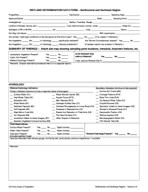
- Begin by entering the project or site name in the designated field, followed by the city or county of the project. This information helps in identifying the location of the wetland assessment.
- Input the sampling date to document when the wetland evaluation took place. This is crucial for referencing conditions at the time of sampling.
- Fill in the applicant or owner information, including names and contact details. This section verifies who is responsible for the property in question.
- Select the appropriate state and include the names of the investigator(s) tasked with assessing the wetland status.
- Record the sampling point's specific location details, such as section, township, and range, along with local landforms and relief types. These fields provide context about the area's topography.
- Complete the latitude and longitude coordinates, ensuring accurate geographic positioning of the sampling point.
- Indicate the soil map unit name and datum. This data is relevant for identifying specific soil characteristics.
- Respond to the questions concerning the climatic or hydrologic conditions and disturbances observed in vegetation, soil, or hydrology. Provide explanations in the remarks section as needed.
- In the summary of findings, attach a site map that shows the locations of sampling points, significant features, and transects to support your data.
- Proceed with the wetland hydrology indicators, where you will check relevant boxes regarding the presence of hydrophytic vegetation, hydric soil, and overall wetland area identification.
- While addressing hydrology, indicate the presence of surface water and document any depth measurements in inches.
- For the vegetation section, provide details about dominant species and cover percentages using scientific names. Fill in the tree, sapling/shrub, herb, and woody vine strata as instructed.
- Document the soil profile by describing matrix colors and redox features, completing depth measurements and other necessary soil information.
- Conclude by saving your changes to the form. You can download, print, or share the completed document based on your needs.
Start filling out your Wetland Determination Form Northeast online today to ensure accurate and timely submission.
To obtain a wetland delineation certificate, you must first conduct a proper wetland delineation study on your property. This process entails collecting data about water, soil, and vegetation. After reviewing this information, you can submit it along with the Wetland Determination Form Northeast to the appropriate agency for certification.