Get Wetland Determination Data Form Northcentral Northeast Region
How it works
-

Open form follow the instructions
-

Easily sign the form with your finger
-

Send filled & signed form or save
How to fill out the Wetland Determination Data Form Northcentral Northeast Region online
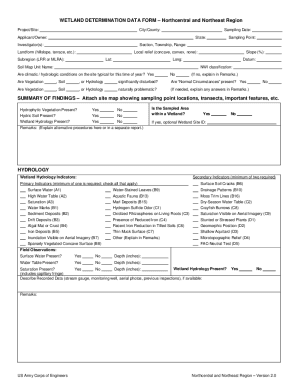
This guide provides step-by-step instructions on how to complete the Wetland Determination Data Form for the Northcentral and Northeast Regions. Designed for users of all experience levels, this resource aims to assist individuals in accurately filling out the form to meet necessary environmental requirements.
Follow the steps to complete the form accurately.
- Press the ‘Get Form’ button to access the Wetland Determination Data Form and open it in your preferred editing tool.
- Begin by entering the project or site name, followed by the city or county where the project is located.
- Fill in the applicant or owner’s name, including the state and sampling point for clarity.
- Document the investigator(s) involved in the wetland determination, along with the section, township, and range information.
- Indicate the landform type, such as hillslope or terrace, and specify the local relief and slope percentage.
- Select the subregion from the list provided and input the latitude and longitude coordinates, as well as the datum used.
- In the climatic/hydrologic conditions section, answer whether conditions are typical for this time of year and provide additional explanations if necessary.
- Address whether vegetation, soil, or hydrology has been significantly disturbed and if 'Normal Circumstances' are present.
- Complete the summary of findings section, including attaching a site map that indicates sampling points and relevant features.
- Answer the hydrological indicators section by checking all applicable primary and secondary indicators observed.
- Document your field observations regarding surface water, water table, and saturation present, including depths.
- Move on to the vegetation section, using scientific names for plants and detailing the various strata with cover percentages.
- Complete the soil section, detailing the profile description and documenting any hydric soil indicators that apply.
- If necessary, provide any remarks for clarification in the remarks section throughout the form.
- Once all sections are filled out, save changes to your form, and choose to download, print, or share the completed document as needed.
Complete your Wetland Determination Data Form online today to ensure accurate documentation.
Wetland delineation parameters include assessing vegetation types, evaluating soil characteristics, and analyzing hydrology. Each of these parameters provides key insights into the wetland's status and health. The Wetland Determination Data Form Northcentral Northeast Region includes detailed guidelines to ensure accuracy in your delineation efforts. Using this form not only helps in proper classification but also supports environmental stewardship.
Industry-leading security and compliance
-
In businnes since 199725+ years providing professional legal documents.
-
Accredited businessGuarantees that a business meets BBB accreditation standards in the US and Canada.
-
Secured by BraintreeValidated Level 1 PCI DSS compliant payment gateway that accepts most major credit and debit card brands from across the globe.