We use cookies to improve security, personalize the user experience, enhance our marketing activities (including cooperating with our marketing partners) and for other business use.
Click "here" to read our Cookie Policy. By clicking "Accept" you agree to the use of cookies. Read less
Read more
Accept
Loading
Form preview
  • US Legal Forms
  • Form Library
  • More Forms
  • More Multi-State Forms
  • Mapping The Ocean Floor Worksheet

Get Mapping The Ocean Floor Worksheet

Name: Date: Mapping the Ocean Floor Worksheet (page 1) Read the information below and then scan the table. On a separate sheet answer the questions that follow. In this activity, you will learn how.

How it works

  1. Open form

    Open form follow the instructions

  2. Easily sign form

    Easily sign the form with your finger

  3. Share form

    Send filled & signed form or save

How to fill out the Mapping The Ocean Floor Worksheet online

This guide provides detailed instructions on how to effectively fill out the Mapping The Ocean Floor Worksheet online. By following these steps, you will enhance your understanding of ocean depths while preparing your worksheet.

Follow the steps to fill out the Mapping The Ocean Floor Worksheet successfully.

  1. Press the 'Get Form' button to access the worksheet and open it in the online editor.
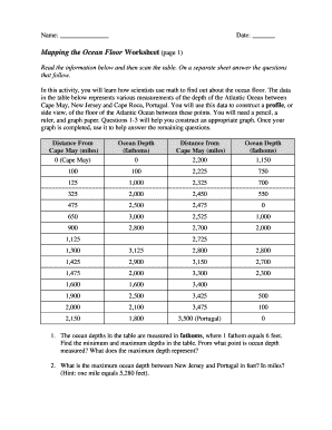
  2. Begin by reviewing the provided information about ocean depth measurements between Cape May, New Jersey, and Cape Roca, Portugal. Familiarize yourself with the data set to prepare for creating the profile.
  3. Answer the first set of questions concerning minimum and maximum depths, ensuring you convert fathoms to feet where necessary. Reflect on what the maximum depth represents in relation to ocean measurement.
  4. For the missing data point at a distance of 2,725 miles, make an educated estimate based on the surrounding values. Document your estimate and explain any assumptions made.
  5. Proceed to construct the graph using the horizontal axis for distance and the vertical axis for ocean depth. Decide on intervals for both axes before plotting the points, and describe any notable depth changes in your graph.
  6. Evaluate whether you have employed the same intervals for both axes and consider their impact on the graph's shape. Document your rationale clearly.
  7. Identify the point on the graph that represents an island and provide a logical explanation for your choice.
  8. Locate the Mid-Atlantic Ridge and label it appropriately on your graph, according to its coordinates obtained from the data.
  9. Calculate the depth of the Mariana Trench compared to the deepest point between New Jersey and Portugal, and create a bar graph comparing these depths alongside notable heights.
  10. Utilize the sonar equation to complete the table by calculating the ocean depth at specified distances and time intervals. Add this data to your graph, connecting all points clearly.
  11. Save your completed worksheet to preserve your changes and then download, print, or share the document as needed.

Complete your Mapping The Ocean Floor Worksheet online to enhance your knowledge and skills.

Get form

Experience a faster way to fill out and sign forms on the web. Access the most extensive library of templates available.
Get form

Related content

Ocean Floor Mapping
Ocean Floor Mapping. Swath bathymetric map of the Bransfield Strait, Antarctica, showing...
Learn more
Fathoms, Ship Logs, and the Atlantic Ocean...
Oct 17, 2019 — They will rely on prior knowledge of seafloor topography, instructions on...
Learn more
Adaptive Earth Science Activities - West Virginia...
Black-Box Ocean Floor Landforms .............. 62 ... Atlases. • Worksheet of places to...
Learn more

Related links form

Download Resume - Daniel Torraca Release Adult Form Pell City Hometown Block Party Vendor Application Saturday, June 6, 2020 AVENUE II EXPENSE CLAIM FORM AVENUE II TIMESHEET

Questions & Answers

Get answers to your most pressing questions about US Legal Forms API.

Contact support

Marie Tharp famously used data from echo-sounding devices to create the first comprehensive maps of the ocean floor. She combined this data with her artistic skills to visualize underwater features. Her pioneering work paved the way for the Mapping The Ocean Floor Worksheet, allowing learners to appreciate the importance of ocean mapping.

Scientists commonly use sonar devices to map the ocean floor. These devices emit sound waves that bounce off the seabed, allowing researchers to create detailed maps. Multibeam sonar systems and side-scan sonar are particularly effective for comprehensive mapping. You can explore how these technologies work further through resources like the Mapping The Ocean Floor Worksheet.

The mapping of the ocean floor theory involves understanding various geological processes affecting the ocean's bed. It emphasizes how features like ridges, trenches, and seafloor spreading contribute to Earth's structure. This theory highlights the importance of accurate mapping for navigation, resource identification, and environmental protection. Engaging with a Mapping The Ocean Floor Worksheet can offer foundational knowledge on these concepts.

The ocean floor is studied using multiple methods. Firstly, scientists employ sonar technology for depth mapping. Secondly, they use submersibles and remotely operated vehicles to explore and photograph the seafloor. Thirdly, sediment cores provide vital information about geological history, and fourthly, satellite data helps researchers analyze large-scale oceanographic patterns. Utilizing a Mapping The Ocean Floor Worksheet can enhance your insights into these methods.

Yes, it is entirely possible to map the ocean floor. Various technologies allow scientists to gather detailed information about underwater terrains. For instance, using sonar systems sends sound waves to measure depth and create visual representations. Resources like the Mapping The Ocean Floor Worksheet can help you understand this complex process.

Sonar - oldest and least expensive method to measure bathymetry. Multibeam - more expensive way to get better coverage in measuring bathymetry. Side-scan sonar - way to produce images of specific objects or ground textures on the seafloor.

Dive and Discover : Oceanographic Tools: Sonar. Echo sounding is the key method scientists use to map the seafloor today. The technique, first used by German scientists in the early 20th century, uses sound waves bounced off the ocean bottom.

Backscatter & Bathymetry MBES systems have become a preferred tool for wide-scale ocean floor mapping due to the benefit of collecting both bathymetric and backscatter data simultaneously.

Sidescan-sonar systems acquire information about the surface of the seafloor, swath bathymetric systems measure seafloor topography, seismic sources map the underlying geologic structure, single-beam echosounders map the depth at a point beneath the vessel.

Today, high resolution seafloor maps are made through multibeam or side scan sonar, either from a ship or from a towed transmitter (Fig. 1.4. 4). Multibeam sonar produces a fan-shaped acoustic field allowing a much a wider area (>10 km wide) to be mapped simultaneously.

Get This Form Now!

Use professional pre-built templates to fill in and sign documents online faster. Get access to thousands of forms.
Get form
If you believe that this page should be taken down, please follow our DMCA take down processhere.

Industry-leading security and compliance

US Legal Forms protects your data by complying with industry-specific security standards.
  • In businnes since 1997
    25+ years providing professional legal documents.
  • Accredited business
    Guarantees that a business meets BBB accreditation standards in the US and Canada.
  • Secured by Braintree
    Validated Level 1 PCI DSS compliant payment gateway that accepts most major credit and debit card brands from across the globe.
Get Mapping The Ocean Floor Worksheet
Get form
Form Packages
Adoption
Bankruptcy
Contractors
Divorce
Home Sales
Employment
Identity Theft
Incorporation
Landlord Tenant
Living Trust
Name Change
Personal Planning
Small Business
Wills & Estates
Packages A-Z
Form Categories
Affidavits
Bankruptcy
Bill of Sale
Corporate - LLC
Divorce
Employment
Identity Theft
Internet Technology
Landlord Tenant
Living Wills
Name Change
Power of Attorney
Real Estate
Small Estates
Wills
All Forms
Forms A-Z
Form Library
Customer Service
Terms of Service
Privacy Notice
Legal Hub
Content Takedown Policy
Bug Bounty Program
About Us
Help Portal
Legal Resources
Blog
Affiliates
Contact Us
Delete My Account
Site Map
Industries
Forms in Spanish
Localized Forms
State-specific Forms
Forms Kit
Legal Guides
Real Estate Handbook
All Guides
Prepared for You
Notarize
Incorporation services
Our Customers
For Consumers
For Small Business
For Attorneys
Our Sites
US Legal Forms
USLegal
FormsPass
pdfFiller
signNow
airSlate WorkFlow
DocHub
Instapage
Social Media
Call us now toll free:
+1 833 426 79 33
As seen in:
  • USA Today logo picture
  • CBC News logo picture
  • LA Times logo picture
  • The Washington Post logo picture
  • AP logo picture
  • Forbes logo picture
© Copyright 1997-2025
airSlate Legal Forms, Inc.
3720 Flowood Dr, Flowood, Mississippi 39232