Loading
Form preview
  • US Legal Forms
  • Form Library
  • More Forms
  • More Multi-State Forms
  • Topographic Map Reading Practice Worksheet Answer Key 2020

Get Topographic Map Reading Practice Worksheet Answer Key 2020-2026

How it works

  1. Open form

    Open form follow the instructions

  2. Easily sign form

    Easily sign the form with your finger

  3. Share form

    Send filled & signed form or save

How to use or fill out the Topographic Map Reading Practice Worksheet Answer Key online

Filling out the Topographic Map Reading Practice Worksheet Answer Key online is an important step in understanding topographic maps. This guide will provide you with clear instructions on each section of the form to ensure that you can complete it effectively.

Follow the steps to fill out the worksheet accurately.

  1. Click ‘Get Form’ button to obtain the form and open it in the editor.
  2. Locate the field for your name at the top of the form. Enter your full name as the user completing the worksheet.
  3. Next, find the date field. Input the current date in the format provided.
  4. In the period section, indicate your classroom period or study session.
  5. Review the map provided in the form. Begin answering the questions one by one, making sure to refer to the map for accurate information.
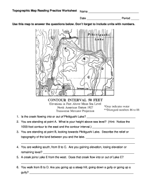
  6. For question one, determine whether the creek is flowing into or out of Pikitigushi Lake. Write your answer clearly in the designated space.
  7. Continue to question two. Here, identify your height above sea level while taking note of the contour lines and intervals indicated on the map.
  8. Proceed to the subsequent questions, providing detailed descriptions and responses as required, such as describing the topography between points and determining elevation.
  9. Ensure that all answers include units where needed, especially in elevation-related questions.
  10. After completing all the questions, review your answers for clarity and accuracy.
  11. Finally, save your changes, and if necessary, download, print, or share the completed form as required.

Begin your Topographic Map Reading Practice Worksheet Answer Key online today and enhance your map reading skills!

Get form

Experience a faster way to fill out and sign forms on the web. Access the most extensive library of templates available.
Get form

Related content

Activity Sheet #4–How to Read a Topographic Map
Use the topographic map in your map packet to answer these questions: What is the...
Learn more
Topographic Maps – Practice Questions and...
Topographic maps that are bounded by lines of latitude and longitude are called. ______...
Learn more
Adaptive Earth Science Activities
Practice cross-sectional drawings from maps. • Have a “Topographic Treasure Hunt”...
Learn more

Related links form

Titration Gizmo Answer Key Application For An Ameren Missouri Permit Transfer Date: Unitedhealthcare Recurring Premium Expense Reimbursement Request Linking Research Questions To Mixed Methods Data Analysis Procedures 1

Questions & Answers

Get answers to your most pressing questions about US Legal Forms API.

Contact support

Contour lines on a map help you understand the elevation changes and the shape of the terrain. Each line represents a specific elevation, with closer lines indicating steeper slopes. By analyzing these patterns, you can identify features like hills and depressions. Practicing with a Topographic Map Reading Practice Worksheet Answer Key can clarify how to read and interpret these essential lines.

A topography test typically assesses your understanding of elevation change, landforms, and spatial relationships on maps. It measures your ability to interpret contour lines and visualize the landscape based on map data. Engaging with a Topographic Map Reading Practice Worksheet Answer Key can significantly aid in preparing for these types of assessments.

Topography tells us about the physical features of the land, including elevations, slopes, and landforms. It provides insights into how these features affect weather patterns and ecosystems. Understanding topography can also guide infrastructure development and conservation efforts. For targeted learning, consult a Topographic Map Reading Practice Worksheet Answer Key to reinforce these insights.

Topography determines various aspects such as climate, biodiversity, and human settlement patterns. For example, hilly regions may receive more rainfall, affecting local ecosystems. Additionally, flat areas tend to be more suitable for agriculture and construction. To better grasp these relationships, use a Topographic Map Reading Practice Worksheet Answer Key as a helpful study tool.

Topography plays a crucial role in shaping ecosystems, agriculture, and urban planning. It influences water drainage, soil types, and vegetation patterns. By understanding topography, you can make informed decisions in land use and environmental management. For learning purposes, refer to a Topographic Map Reading Practice Worksheet Answer Key that elaborates on these concepts.

You can obtain topographic map data from various sources, including government agencies and online mapping services. The U.S. Geological Survey (USGS) provides freely accessible maps. Additionally, consider using platforms like UsLegalForms to find worksheets and resources that help interpret and utilize topographic data effectively, including a Topographic Map Reading Practice Worksheet Answer Key.

Topography is influenced by three main factors: elevation, slope, and landforms. Elevation refers to how high or low land is above sea level, while slope indicates the steepness of the terrain. Landforms include features like mountains, valleys, and plains. Together, these factors shape the landscape and can be explored further using a Topographic Map Reading Practice Worksheet Answer Key.

0:34 3:47 How to Read a Topo Map - YouTube YouTube Start of suggested clip End of suggested clip Spend. Some time with a map of a familiar area and see if you can pick out terrain features just byMoreSpend. Some time with a map of a familiar area and see if you can pick out terrain features just by looking at the contour. Lines.

It is given as a ratio of inches on the map corresponding to inches, feet, or miles on the ground. For example, a map scale indicating a ratio of 1:24,000 (in/in), means that for every 1 inch on the map, 24,000 inches have been covered on the ground. Ground distances on maps are usually given in feet or miles.

3:12 7:30 How to Read Contour Lines on a Topographic Map - YouTube YouTube Start of suggested clip End of suggested clip And I stand on this next contour line knowing that the contour interval is 10 feet I've gone up 10MoreAnd I stand on this next contour line knowing that the contour interval is 10 feet I've gone up 10 feet in elevation. So. This line right here is the 910 foot contour.

Get This Form Now!

Use professional pre-built templates to fill in and sign documents online faster. Get access to thousands of forms.
Get form
If you believe that this page should be taken down, please follow our DMCA take down processhere.

Industry-leading security and compliance

US Legal Forms protects your data by complying with industry-specific security standards.
  • In businnes since 1997
    25+ years providing professional legal documents.
  • Accredited business
    Guarantees that a business meets BBB accreditation standards in the US and Canada.
  • Secured by Braintree
    Validated Level 1 PCI DSS compliant payment gateway that accepts most major credit and debit card brands from across the globe.
Get Topographic Map Reading Practice Worksheet Answer Key
Get form
  • Adoption
  • Bankruptcy
  • Contractors
  • Divorce
  • Home Sales
  • Employment
  • Identity Theft
  • Incorporation
  • Landlord Tenant
  • Living Trust
  • Name Change
  • Personal Planning
  • Small Business
  • Wills & Estates
  • Packages A-Z
  • Affidavits
  • Bankruptcy
  • Bill of Sale
  • Corporate - LLC
  • Divorce
  • Employment
  • Identity Theft
  • Internet Technology
  • Landlord Tenant
  • Living Wills
  • Name Change
  • Power of Attorney
  • Real Estate
  • Small Estates
  • Wills
  • All Forms
  • Forms A-Z
  • Form Library
  • Legal Hub
  • About Us
  • Help Portal
  • Legal Resources
  • Blog
  • Affiliates
  • Contact Us
  • Delete My Account
  • Site Map
  • Industries
  • Forms in Spanish
  • Localized Forms
  • State-specific Forms
  • Forms Kit
  • Real Estate Handbook
  • All Guides
  • Notarize
  • Incorporation services
  • For Consumers
  • For Small Business
  • For Attorneys
  • USLegal
  • FormsPass
  • pdfFiller
  • signNow
  • altaFlow
  • DocHub
  • Instapage
Form Packages
  • Adoption
  • Bankruptcy
  • Contractors
  • Divorce
  • Home Sales
  • Employment
  • Identity Theft
  • Incorporation
  • Landlord Tenant
  • Living Trust
  • Name Change
  • Personal Planning
  • Small Business
  • Wills & Estates
  • Packages A-Z
Form Categories
  • Affidavits
  • Bankruptcy
  • Bill of Sale
  • Corporate - LLC
  • Divorce
  • Employment
  • Identity Theft
  • Internet Technology
  • Landlord Tenant
  • Living Wills
  • Name Change
  • Power of Attorney
  • Real Estate
  • Small Estates
  • Wills
  • All Forms
  • Forms A-Z
  • Form Library
Customer Service
  • Legal Hub
  • About Us
  • Help Portal
  • Legal Resources
  • Blog
  • Affiliates
  • Contact Us
  • Delete My Account
  • Site Map
  • Industries
  • Forms in Spanish
  • Localized Forms
  • State-specific Forms
  • Forms Kit
Legal Guides
  • Real Estate Handbook
  • All Guides
Prepared for you
  • Notarize
  • Incorporation services
Our Customers
  • For Consumers
  • For Small Business
  • For Attorneys
Our Sites
  • USLegal
  • FormsPass
  • pdfFiller
  • signNow
  • altaFlow
  • DocHub
  • Instapage
Social Media
Call us now toll free:
+1 833 426 79 33
As seen in:
© Copyright 1999-2026 airSlate Legal Forms, Inc. 3720 Flowood Dr, Flowood, Mississippi 39232
  • Your Privacy Choices
  • Terms of Service
  • Privacy Notice
  • Content Takedown Policy
  • Bug Bounty Program