Loading

Open form follow the instructions

Easily sign the form with your finger

Send filled & signed form or save
How to fill out the Locating An Earthquake Epicenter Activity online
This guide provides a detailed walkthrough for successfully completing the Locating An Earthquake Epicenter Activity online. Ideal for users of all experience levels, it ensures you can efficiently locate earthquake epicenters using provided seismograms and travel-time graphs.
Follow the steps to complete the Locating An Earthquake Epicenter Activity
- Click the ‘Get Form’ button to access the form and bring it up in your preferred online editor.
- Begin by reviewing the objectives of the activity. Familiarize yourself with the concepts of P, S, and surface waves and how they relate to seismograms.
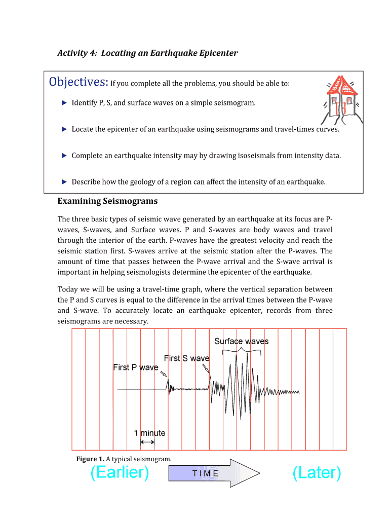
- In the first part of the form, analyze the sample seismogram provided as Figure 1. Identify the arrival times of the first P-wave and S-wave.
- Using Figure 2, calculate the difference in arrival times for the three specified distances (700 miles, 450 miles, and 2500 miles). Input these values in the designated fields.
- Refer to the travel-time graph to determine the distance from the epicenter for the recorded times in Figure 1. Fill in this distance in the appropriate field.
- Examine the seismograms from Figure 3, calculating distances for each station and inputting these in the epicenter data table, Table 1.
- Use a drawing compass to outline circles on the map around each station, ensuring the radii correspond to their distances from the epicenter.
- Respond to the final queries regarding overlaps of circles and corresponding locations of the earthquake. Carefully consider your responses and place them in the provided fields.
- Once all sections are completed, review your inputs for accuracy. You can then save changes, download, print, or share your completed form.
Complete the Locating An Earthquake Epicenter Activity online today and enhance your understanding of seismic wave analysis.
Experience a faster way to fill out and sign forms on the web. Access the most extensive library of templates available.
Related content
Locate the epicenter of an earthquake using seismograms and travel‐times curves...
The center of the circle will be the location of your seismograph. The epicenter of the...
To find on a map the location of the epicenter of an earthquake. Materials and Equipment:...
Get answers to your most pressing questions about US Legal Forms API.
What is the process used by the seismologist to locate epicenters?
Seismologists locate epicenters by analyzing seismic waves captured by various monitoring stations. They calculate the difference in arrival times of the waves to determine distances from each station, then use triangulation to pinpoint the epicenter. Participating in the Locating An Earthquake Epicenter Activity gives you a hands-on approach that demystifies the scientific techniques seismologists use daily.
How to simulate an earthquake for a science project?
To simulate an earthquake for a science project, you can create a simple shake table using materials like cardboard and a base with rubber bands. Then, build a small model structure on the table and simulate shaking. Incorporating this Locating An Earthquake Epicenter Activity allows you to connect your simulation with real seismic data and helps your audience understand the science behind earthquakes.
Why is it important to know the exact location of the epicenter?
Knowing the exact location of the epicenter is crucial for assessing the earthquake's impact on surrounding areas. It helps emergency response teams allocate resources effectively and informs the public about potential dangers. Engaging with the Locating An Earthquake Epicenter Activity emphasizes the importance of precise location tracking during seismic events.
How do you plot the epicenter of an earthquake?
To plot the epicenter of an earthquake, begin by collecting the distance data from multiple seismic stations. Then, use a map to draw circles around each station, with the radius representing the distance from the station to the epicenter. The point where all circles intersect indicates the epicenter, making the Locating An Earthquake Epicenter Activity an enlightening experience for anyone interested in geology.
How do we determine the location of the epicenter of an earthquake?
Determining the location of an earthquake's epicenter involves a method called triangulation. By analyzing data from at least three different seismic stations, you can pinpoint where the waves converge to indicate the epicenter. This process is critical in the Locating An Earthquake Epicenter Activity, as it showcases how seismic data helps identify earthquake sources effectively.
How do you get to know the location of an earthquake epicenter?
You can find the location of an earthquake epicenter by accessing seismic data from nearby monitoring stations. These stations collect data about seismic waves, which then undergo analysis to pinpoint the epicenter's exact location. Engaging in this Locating An Earthquake Epicenter Activity provides valuable insights into seismic monitoring and helps you stay informed about earthquakes.
How to calculate how far a location is from the epicenter?
To calculate the distance from a location to the earthquake's epicenter, you can use the seismic wave data recorded by seismographs. By determining the difference in arrival times between P-waves and S-waves, you can find the distance to the epicenter. This Locating An Earthquake Epicenter Activity helps you understand the relationship between seismic waves and distance, enhancing your knowledge about earthquakes.
How to calculate the epicenter of an earthquake?
To calculate the epicenter of an earthquake, you will need the arrival times of P and S waves from several seismic stations. By measuring the difference in arrival times, you can determine the distance to the epicenter. When you plot these distances from different stations on a map, the point of intersection reveals the epicenter, connecting directly with the Locating An Earthquake Epicenter Activity.
How did geologists locate the epicenter of an earthquake?
Geologists locate the epicenter of an earthquake by analyzing seismic wave data recorded by seismographs. They determine the P and S wave arrival times, which helps them calculate distances from various seismic stations. By overlapping these distances on a map, they pinpoint the epicenter. This method is an essential part of the Locating An Earthquake Epicenter Activity.
How do you locate the epicenter of an earthquake?
To locate the epicenter of an earthquake, you begin by collecting seismic data from multiple stations nearby. Measure the time difference between the arrival of P and S waves to determine the distance from each station to the epicenter. By plotting these distances on a map, you can identify the epicenter's location, making it easier to understand the Locating An Earthquake Epicenter Activity.
Use professional pre-built templates to fill in and sign documents online faster. Get access to thousands of forms.
If you believe that this page should be taken down, please follow our DMCA take down process here.