
Open form follow the instructions

Easily sign the form with your finger

Send filled & signed form or save
How to fill out the Topographic Map Reading Worksheet Answer Key Pdf online
This guide provides a step-by-step approach to filling out the Topographic Map Reading Worksheet Answer Key Pdf online. Whether you are new to this type of document or have some experience, this comprehensive resource will assist you in navigating and completing the form efficiently.
Follow the steps to complete the Topographic Map Reading Worksheet Answer Key Pdf.
- Click ‘Get Form’ button to obtain the form and open it in the editor.
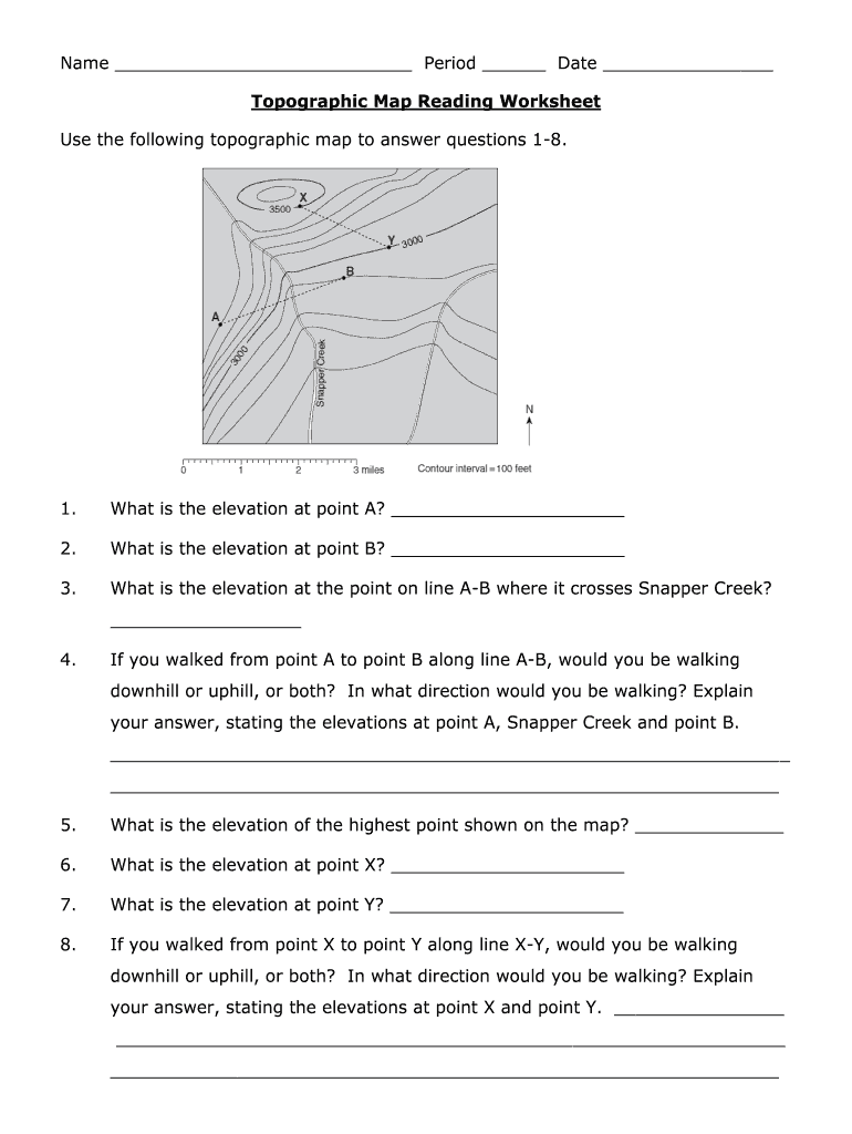
- Review the topographic map provided with the worksheet. Familiarize yourself with the elevations and landmarks indicated on the map as these will help in answering the questions.
- Begin answering the questions from 1 to 8 sequentially, starting with the elevation at point A. Write your answers in the designated spaces provided next to each question.
- Continue to questions 9 to 33, making sure to reference the topographic map from Palo Duro Canyon State Park in west Texas. Pay attention to the specific details each question requests.
- For questions that ask for an explanation, such as the direction of elevation changes between points, provide clear and concise reasoning supported by your answers to earlier questions.
- Once all answers have been entered, review the entire form to ensure all required fields are filled out correctly and all calculations are accurate.
- When you are satisfied with your answers, you can save changes, download the completed worksheet, print it, or share it as needed.
Start competing documents online to enhance your topographic map reading skills.
Experience a faster way to fill out and sign forms on the web. Access the most extensive library of templates available.
Related content
Use the topographic map in your map packet to answer these questions: What is the...
Topographic Maps – Practice Questions and Answers. Revised October 2007. 1. In the...
Use a key or field guide to identify the rock types in the samples. • Use a geologic map...
Get answers to your most pressing questions about US Legal Forms API.
How do you analyze topography?
Topography is measured by to connecting points of same elevation. These points are known as the topographic contours. Slope is measured by the distance between one point to another point and this distance is divided by the lateral distance between them.
What are the numbers around a topographic map?
These numbers represent two grid systems that can be used to find your exact location. The first is called latitude and longitude. The exact latitude and longitude is given at each corner of that map and at equally spaced intervals between the corners. The second is called UTM's.
How do you read a topographic map?
0:34 3:47 How to Read a Topo Map - YouTube YouTube Start of suggested clip End of suggested clip Spend. Some time with a map of a familiar area and see if you can pick out terrain features just byMoreSpend. Some time with a map of a familiar area and see if you can pick out terrain features just by looking at the contour. Lines.
How do you read topography numbers?
The map's scale tells you how detailed your map is. A 1:24000 scale, for example, means one inch on the map equals 24,000 inches of real-world terrain. If the scale ratio had a number like 1:65,000, though, that would mean that each inch on the map covered 65,000 inches of terrain.
How do you read a topographic scale?
How to read a topographic map The closer together the contour lines, the steeper the slope. The further apart the contour lines, the gentler the slope. If you see contour lines that form a V pointing uphill, you're looking at a valley. ... If you see contour lines that form a V pointing downhill, you're looking at a ridge.
How do I read a topographic map on Google Maps?
Hover your mouse pointer over Layers in the bottom left corner of the map area to reveal a menu, and then click Terrain in the menu to show topography and elevation. Note: Make sure the toggle for View topography and elevation is turned on in the Terrain pop-up at the bottom of the map.
How do you find the contour lines on a topographic map?
3:40 7:30 How to Read Contour Lines on a Topographic Map - YouTube YouTube Start of suggested clip End of suggested clip So. This line right here is the 910 foot contour. Now if I go down the hill I would take 900. MinusMoreSo. This line right here is the 910 foot contour. Now if I go down the hill I would take 900. Minus 10 and this would be the 890 foot contour going all the way around.
What does 1 50 000 topographic maps mean?
Medium-scale maps (e.g. 1:50 000) cover smaller areas in greater detail, whereas small-scale maps (e.g. 1:250 000) cover large areas in less detail. A 1:250 000 scale national topographic system (NTS) map covers the same area as sixteen 1:50 000 scale NTS maps.
Use professional pre-built templates to fill in and sign documents online faster. Get access to thousands of forms.
If you believe that this page should be taken down, please follow our DMCA take down process here.